A collection of race reports and other writings of and about ultrarunning, trail running, and other running related topics with a strong focus on the East Coast. The "Beast Coast" has a strong trail running community and some amazing events; this blog aims to showcase some of that.
This was my first run since Sunday and my first night trail run since August. I got knocked down by a pretty bad cold (not COVID, I got tested) this past week and took a few days off to recover. I started feeling crappy and sneezing Monday evening. Tuesday and Wednesday were full blown "I'm sick" days complete with sinus congestion, sinus headache, runny nose, and severe reduction of energy levels. Things started getting better Thursday, but the energy wasn't back and I didn't want to add undue stress to the body while still recovering. Friday felt good other than a bit of stubborn congestion that was still hanging around. I decided it was time to go for a test run. It was the right decision.
It was also my first night run that finally felt like an autumn evening run. The air was cool, crisp, and still. The moon was bright and the sky was clear. The only sounds were my feet moving through the leaf litter and the sniffles from my still slightly runny nose. For having not run in almost a week and just getting over a cold, I moved surprisingly well and with minimal effort. Maybe my legs needed the break too. My headlamp lit the trails I've run so many times in daylight, surprising me how different these trails that I think I'm so familiar with can look after dark. Deer eyes and spider eyes glowed when the light from my headlamp was aimed in their direction. It's an experience that will always remind me of my overnight trip running the Batona Trail when my mind started playing tricks on me in response to all those glowing eyes staring at me from the dark.
It sure did feel good to run again after almost a week of no running and a few days off being sick. And to be able to run the same trails I always run, but in a new way. It's a reminder to me to be grateful and realize how blessed I am to have found an activity I enjoy pursuing with passion and that I have the physical capabilities to do so.
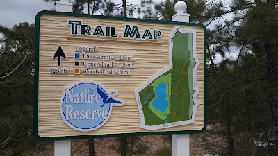
I've been running at the Egg Harbor Township Nature Reserve for a little over 5 years now and have easily put in hundreds of trail miles there. Just this past summer I feel like I've finally found the ideal trail route there, in my opinion. I thought I had the best route already figured out a while back, but it included an out and back along a power line cut that I never really cared for because A: it's and out and back and B: it is one of the few sections that is in full sun. This updated route omits that power line out and back and adds a small trail loop at the beginning on a less traveled trail that I had always overlooked.
EHT Nature Reserve Grand Tour Route Overview/Walkthrough
From the Zion Rd. parking lot you’ll hop on the Upper Trail and head out towards the right beginning a loop around the lake in a counter clockwise direction. You won’t be on that trail long though. Pretty much as soon as you see the lake from the top of the sledding hill (a little past 0.1 mile) you’ll see the woods trail cut off to your right into the woods. Follow those orange markers.
This trail will take you through the most heavily wooded area of the reserve. At about 0.25 mile the trail forks. Stay right for a little jog through the woods back towards Zion Rd. You’ll run with Zion Rd. in sight for a short while (I promise this is the most road you’ll see for the entire route) and then the trail will turn left and merge with what feels like a fire road at about the 0.45 mile mark. Follow this straight away through the woods until you come to a “T” at about 0.7 miles. Make a right there then keep your eyes peeled for trail markers so you don’t miss the next left otherwise you will end up in a storm retention basin if you stay straight on that trail.
The Woods Trail will lead you back towards the lake, but just before you reach it the trail will turn back in a north east direction into the woods again. Follow the orange markers until you are almost at the powerline cut (about 1.6 miles). At this point you will follow a very short trail across the powerline cut to pick up the 0.7 mile trail on the other side. At the halfway point of this section you’ll see Bayside Rd. as the trail turns and begins to make its way back towards the powerline cut.
You’ll then follow the powerline cut along the wood edge until you see the concrete tubes. At that point the trail cuts back into the woods for a bit and you’ll be back on the Upper Trail. Follow this past the concrete tubes and enjoy the artwork of New Jersey’s natural areas. Then enjoy the view of the lake to your left from the Upper Trail.
The trail will cut left at about 2.9 miles. Make the left, but before the trail reenters the woods, cut right and continue to follow the powerline cut just a bit further along the wood edge. At 3.0 miles a short “unofficial” trail will be on your left. Take that to hop on the “Smart Trail” loop and run that counter clockwise. This will take you back to the Upper Trail which you can follow past the Schoolhouse Rd. parking area. Follow this through the woods and you’re almost back to the Zion Rd. parking lot!
You could bail here if you want, but you would miss out on the Lake Trail portion of the Grand Tour. You don’t want that, so make a hard left and enjoy the shade between here and the gazebo. Hang right there and follow the narrow trail along the Phragmites at the water’s edge. Once it opens up, you’ll have to deal with full sun for a short while. Some sections are pretty sandy around the north edge of the lake so if you plan on a high mileage day, gaiters aren’t a bad idea.
Circle the lake and head to the far northeast corner. There you’ll find the steepest climb of the entire route and at the top is the Upper Trail. Hop on it and take a right. Follow this trail until about the 4.75 mile mark when you see a second bench overlooking the lake. A short connector trail is off to the right just after that bench. Follow that heading down the slate stairs to get back on the Lake Trail. Follow that passing the sledding hill again (this time from the bottom) the last quarter mile back to the Zion Rd. lot. Congrats! You completed the Grand Tour of the EHT Nature Reserve. You have now seen nearly all trails and areas of the reserve!
If you live in or around EHT and enjoy trail running, I highly recommend this route. It's a great area for runners new to the trails as it is all nontechnical and runnable. The route is about 5 miles and pretty much showcases all areas the Nature Reserve has to offer without any out and backs or retracing your steps at all. The main reason I run the majority of my trail miles at the EHT Nature Reserve is simply because they are the closest trails to home for me. I used to get a bit annoyed at running short loops to get any decent mileage there. Now with a 5 mile route without any out and backs or repeated loops, I feel like I have the perfect distance to run loops for long trail runs. From dusty, sandy trails overlooking the lake to shady trails with your footfalls cushioned by a layer of pine needles, the EHT Nature Reserve offers a diverse trail network within a relatively small area.
Of course there are many other variations of loops and routes you can create and adjust to your liking on the trails there. So get out and enjoy!
Slideshow of the Fat Sass Switchback Challenge. Photo credit for all photos used in the
slideshow and blog post goes to the wonderful volunteers that made this an amazingly fun event!
The Fat Sass Switchback Challenge is a distance/timed event orchestrated bySassquad Trail Running, a division of Core Total Training and Fitness LLC. The event in its inaugural year (2018) offered runners a 5k distance option or the choice of two timed event options of three or six hours. I opted for the six hour challenge. It was managed as a self-supported fat ass style race, so no entry fees, no aid, and no swag. Even without aid provided, there was a designated park table for runners to donate community aid to and it was about as good as any aid station I’ve passed through. The organizers did ask in place of an entry fee that runners bring non-perishable food items to donate toLivingston Neighbors Helping Neighbors, a nonprofit organization that assists Livingston residents struggling with unexpected hardships by providing short-term financial and in-kind support. I was happy to contribute to the cause and have the opportunity to run a race on some new trails.
The course is a trail loop just a little over a mile (roughly 1.05 miles according to my Garmin data) in
Near the end of the one mile loop.
distance. The elevation gain per loop is 274 feet according to my Garmin data and 313 feet according to my Strava data, so trust whichever data set you feel is more accurate. Runners take on the course in a clockwise direction starting at the Locust Grove picnic area of South Mountain Reservation in Millburn, NJ. The trail starts with a climb up about 5 switchbacks (hence the name of the event) of primarily smooth trail for about a half mile before reaching the top of the ascent. There is then a short stretch (less than a tenth of a mile) of flat paved road before making a right back onto the trails. From there it’s about a half mile descent down more technical, rocky trails before returning to the picnic area.
I registered for this race to use it as a long training run with a good amount of elevation gain ran at a faster pace than I’m willing to push myself to without any competition. It was also a matter of convenience; I was visiting my in-laws the weekend of the race and the park it was held at was only about an hour from their house. For all those reasons and no entry fee while donating to a good cause, I couldn’t resist. Having never visited the area where the race was, I wasn’t sure what to expect of the trails. I knew there would be some elevation gain because the description on the Ultrasignup page said that each lap had about 291 feet of gain. However, I never did the math to figure how much gain I would accumulate based on distance goals until the night before the race when I was telling a friend about it. I casually told him that I planned on running thirty some miles in the six hour period. Then I did an estimate of the math in my head: 30 laps X 300 feet = 9,000 feet of gain. Shocked, I redid the math using a calculator: 30 laps X 291 feet = 8,730 feet. At this point in the conversation, in near disbelief, I told my friend that that’s more gain than Hyner 50k and I likely wouldn’t be running as far as I had planned to in the six hours. Setting goals for timed events that are pretty much out of my reach seems to be a habit for me. I did the same thing when getting ready for the six hour Running with the Devil.
Thankful that I figured out how much tougher of a race this was going to be than I expected the night before rather than during the race, I tried to get some good rest before my early alarm went off. Unfortunately, a good night’s sleep was not to be had. This weekend was the night of the Fourth of July fireworks display so the kids got to bed late to begin with after that. Then one of the two woke up a couple times during the night and had trouble getting back to sleep. So, after a few hours of
A rocky, but not the rockiest descent.
broken sleep I got up, ate some breakfast (peanut butter sandwiches), and drove to the park. I got there early enough to get situated. I checked in, dropped off my charity food donation, added my community aid ofSwedish Fish and olives to the aid table, and got my personal aid station organized. Since this was a self-supported race I brought enoughGatorade and calories to get me through the entire six hours. Since I’m a bit frugal and I only had one gel on hand, all of my calories came from that single gel, three cans of Wal-Mart brand cola, and a tube ofgreen cake frosting. I know, sounds gross, but it works and it’s not like gels really taste all that great anyway. Since it was at most a six hour race, my plan for fueling didn’t rely on any real food. I basically just wanted quick energy from simple carbs and some caffeine. The soda and frosting met all my needs.
After a few words from the RD, Kim Levinsky, the race began. Interestingly, and maybe it was just for the sake of simplicity, all runners (5k, 3 hour, and 6 hour) started simultaneously. I guess in this manner, a single clock could be used to time all three events simultaneously. Another interesting part of the organization of the race to me was the lap counting system that was used. At the completion of each lap timed event runners would record their place at the time on a chart that had all the runners’ names in that event listed. Similarly, 5k runners recorded their time rather than place at each lap. With this system, you always knew what place you were in and could get an idea of how far other runners were in front of and behind you. A volunteer was there to assist at all times as the board could get a little confusing especially after a few hours of running trail laps in the heat and your brain is getting a bit foggy.
The check in board used to record your place after every lap.
After considering the amount of gain I had in store for me and my readjusted goal of aiming for up to 30 laps rather than thirty-something laps, I went out at a pace that I thought would get me close to that goal. This meant running the entire climb during the first lap which wasn’t bad as it was not too technical and not too steep thanks to all the switchbacks. However, I knew full well that after a few laps I would certainly be hiking portions of the climb. I ran the flat paved section at the top at a medium effort then tried to let gravity do the work and stay light on my feet as I flew down the technical descent to complete my first lap in about 10:54. This was good enough to put me in first place at the time. I was able to maintain that pace and running the entire course for about the first four laps. After that, my times started to slow a bit as I started hiking portions of the climb. It was somewhere around the fourth lap check in that another runner I had been yo-yoing with got to the check in right ahead of me. It turns out he was another six hour runner who had been checking in as second just behind me for the first few laps. He was a bit confused when filling in his place at the board when he realized he was now in first. Which is another point that made the lap counting system interesting. It was hard to tell who you were racing against unless you happened to be at the lap check in with them. There were no markings on the bibs, so unless you asked you couldn’t tell who was a six hour or a three hour runner. Hence the reason for the other runner’s confusion when he got the lead.
I continued cranking out laps in second place for a couple more hours maintaining a pretty steady pace. The mental challenge of a timed event on a short loop was something I haven’t dealt with very often. I approached it the same way I approach a distance event: break it up into manageable sections and then comfort yourself every time you reach one of those check points. For this event, I broke it down into two hour blocks. The first two hours seemed to go surprisingly fast. I told myself “that wasn’t so bad, just do that two more times!”. The middle two hours were the toughest mental struggle for all the normal reasons: it got a bit warm, I was beginning to tire, and there was still a pretty long way to go. Once I got through that and into the final two hours, things began to turn around. I knew at this point it was time to push and see what’s left in the tank.
The view from a point midway up the switchbacks.
I don’t remember exactly where, but somewhere near the middle of the race I realized at check in that I had been passed by a six hour runner and was now in third. I had no idea who it was for the reasons I mentioned earlier. I continued in third place until there was a little over a half hour left. At this point if figured I would have enough time to finish my current lap and run two more before time ran out as long as I maintained my pace of around 13 to 14 minute laps. As I’m going over this and calculating the time in my head while finishing up the climb and reaching the paved section I caught sight of a few runners ahead of me. At this point I knew they had to be six hour runners, but I wasn’t sure if they were runners I was lapping or if one of them may be the second place runner. I didn’t catch them before the check point where I saw that I was still in third. Not knowing if I was taking over the second place position or not, I skipped stopping for aid this lap and decided to run this second to last lap as hard as I could. I figured if I did just take second place this would give me a bit of a gap ahead of him before he finds out at the next check in. If I was still in third, it would at least give me a chance to catch the second place runner wherever they were or I could at least say I gave it my all to try to catch them. Running my second to last lap as fast as one of my early laps I reached the check in to find out that I was in fact in second place. Knowing this motivated me to keep my pace up for my final lap and finish strong in second place with a total of 26 laps (about 27.2 miles).
The scene just before the start of the race.
The highlights for me during this race weren’t really about me or even specifically running. What I thought made this race great was the organization and volunteers that made it happen. There aren’t many trail races in NJ and even less trail ultramarathons. I’m so excited that Sassquad Trail Running has started organizing these events in NJ that are more convenient for me than driving to the middle of PA. During the race it was great seeing many of the volunteers taking time to run a few laps while they had downtime from their volunteer duties. During one of my laps, a volunteer took note of the Hyner socks I was wearing and commented about Hyner being tough and how this race compares. I replied with something along the lines of “This is tougher than Hyner in a lot of ways”. Strictly looking my Strava elevation gain data (8,142 feet for Fat Sass versus 7,507 feet for Hyner), the Fat Sass was tougher than Hyner. In a way, I feel that Hyner relieves a bit of the suffering experienced while running it with the beautiful scenery you enjoy along the way. Even with the arguably more technical terrain of the trails at Hyner, the grueling nature of repeating a one mile loop for six hours I still feel was more challenging than anything I experienced while running Hyner.
Last weekend I had the opportunity to explore a new area and some new trails (new to me anyway) in South Jersey. I visited the Maurice River Bluffs Preserve in Millville, NJ managed by The Nature Conservancy. I first learned of the preserve through a coworker who recommended I check it out if I want some trails with hills to run. Coming from a non running, South Jersey native I honestly did not have high expectations for the trails there. After checking out the trail map and the website, I figured that in the worst case scenario I could at least get a four mile loop on some new trails. When an open Saturday presented itself, I made the 45 minute drive from home hoping for the best case scenario. Arriving at the entrance, I was greeted by The Nature Conservancy sign and followed the narrow, single lane dirt road through the woods to the parking lot. The lot was nearly full and I immediately worried that the trails would feel crowded. I was pleased after the completion of my first lap around the perimeter of the trail system to find that it was about a 4.4 mile loop and did not feel crowded at all. I attribute this to the intricacy of the trail network. I believe the variety of options of interconnected trails allows visitors to disperse enough so as to not make the 535 acre preserve feel overcrowded even at peak use times.
Trail map.
Besides the variety of trails offered, another aspect of the preserve that impressed me was the hills. Don’t get me wrong, it is still South Jersey, but my 20 mile run got me over 1400’ of elevation gain according to Strava. I realize that 1400’ is laughable in many other areas, but for us flatlanders in South Jersey it makes this reserve valuable elevation training ground.
I already mentioned how impressed I was with the depth and variety of the many connected trails at the preserve. Which is why I was so surprised to find that it appeared that they were in the process of expanding the trail network at the preserve. At many points during my run I noticed unblazed trail marked with flagging. During my third lap around the perimeter I decided to get adventurous and follow one of these new trails. The appeared to have been marked and cleared for some time as I saw many mountain bike tire tracks along the lengths of them. I expect the trail map to be updated to include these newly blazed trails in the near future.
Lastly, I was impressed by the beauty of the sights throughout the preserve. A good portion of the perimeter loop follows the Maurice River and offers some great vistas along the way. The remainder of the trails wind mostly through forests dominated by pine, red cedar, and wild black cherry trees offering a good deal of shade. Maybe the reason the preserve appeared so attractive to me was just because the whole area was new to me, but maybe not. I’ll let you be the judge…